Home
»
Selfie Drones for 3D Modelling, Geological Mapping and Data Collection: Key Examples from Santorini Volcanic Complex, Greece
Selfie Drones for 3D Modelling, Geological Mapping and Data Collection: Key Examples from Santorini Volcanic Complex, Greece
3 years 11 months ago
The article “Selfie Drones for 3D Modelling, Geological Mapping and Data Collection: Key Examples from Santorini Volcanic Complex, Greece” was presented at GISTAM 2020.
The authors are Fabio Luca Bonali, Varvara Antoniou, Othonas Vlasopoulos, Alessandro Tibaldi and Paraskevi Nomikou, as a result of the collaboration between:
- Department of Earth and Environmental Sciences, University of Milano-Bicocca,
- CRUST- Interuniversity Center for 3D Seismotectonics with Territorial Applications (Italy),
- Department of Geology and Geoenvironment, National and Kapodistrian University of Athens.
Abstract:
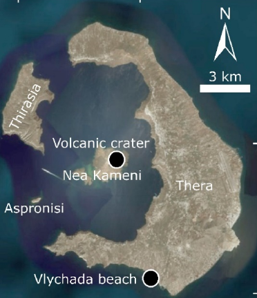
In the present work, we tested the use of selfie drones as a tool for 3D modelling, geological mapping, and data collection. The model we used is a 0.300-kg multirotor quadcopter being equipped with a 1/2.3-inch CMOS sensor capable of capturing 12 Megapixel pictures, attached to a 2-axis mechanical gimble and with approximately 16 minutes of flight time. Test sites are located in Santorini and are characterised by different settings: i) the 1570-1573 AD volcanic crater area, in Nea Kameni island, has a mostly horizontal topography; ii) the outcrop along Vlychada beach, showing layers of the Late Bronze Age (also well-known as Minoan) eruption, has mostly vertical topography. By applying the Structure from Motion techniques to pictures collected using the selfie drone, we were capable of: i) reconstructing the two sites with centimetric to subcentimetric resolution; ii) recognizing geological features on very high-resolution Digital Surface Models and Ortomosaics; iii) mapping vertical cliffs made up of volcanic deposits on 3D Digital Outcrops Models; iv) collect new quantitative data for both sites.
Introduction:
Field studies and data collection are vital for mapping and understanding the active geological processes on Earth, particularly for those that induced superficial deformations like earthquakes and shallow magmatic processes (e.g. Bonali et al., 2012; Tibaldi et al., 2017). However, field studies and direct observations are very often limited by specific field-related conditions such as the inaccessibility of key outcrops due to their location in remote or dangerous areas (e.g. Tibaldi et al., 2008). The Structure from Motion and Multiview stereo (SfM-MVS) photogrammetry techniques, where photos are collected using Unmanned Aerial Vehicles (UAVs), are nowadays widely used in Earth and Environmental Sciences to overcome these problems providing high-resolution 3D Digital Outcrop Models (DOMs), digital surface models (DSMs) and Orthomosaics as results (e.g. Bonali et al., 2019a; Fallati et al., 2019). Most people dealing with geological and geohazard studies use different types of UAVs: balloons, multi-rotor, fixedwing and hybrid. Whereas balloons do not need fuel or battery, on the other hand they cannot be remotely controlled. Hybrid types allow to switch between flying like a fixed-wing aircraft and hovering like a multi-rotor one. The fixed-wing type can cover larger areas in a smaller time frame using high quality cameras, but such model is more difficult to be transported and more expensive than multi-rotor UAVs. Based on our experience, the latter can fly at very low heights attaining a great field resolution, and much more importantly, take-off and landing operations are easier than for fixed-wing models; this is crucial especially in difficult logistic terrains (e.g. outcropping lavas, Bonali et al., 2019a).
In the present work we tested the use of the so called “selfie drones” - quadcopter type - to produce very high-detailed 3D DOMs of relevant outcrops for geological mapping, data collection and scientific dissemination. As case studies we selected two sites within the Santorini volcanic complex (with different characteristics: i) the 1570-1573 AD volcanic crater in Nea Kameni island and ii) an outstanding vertical outcrop showing volcanic layered deposits, along the Vlychada Beach, southern Santorini.
Visit also:
